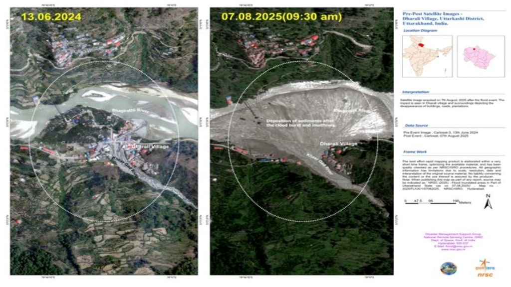
The National Remote Sensing Centre (NRSC), a key part of the Indian Space Research Organisation (ISRO), has provided crucial information to rescue operations following a catastrophic flash flood that struck Dharali and Harsil in Uttarakhand on August 5. NRSC used data from its high-resolution Cartosat-2S satellite and assessed the extent of the damage, offering information to the rescue teams on the ground.
Satellite Insights Aiding Rescue & Relief Ops
— ISRO (@isro) August 7, 2025
ISRO/NRSC used Cartosat-2S data to assess the devastating Aug 5 flash flood in Dharali & Harsil, Uttarakhand.
High-res imagery reveals submerged buildings, debris spread (~20ha), & altered river paths, vital for rescue teams on… pic.twitter.com/ZK0u50NnYF
The flash floods led to heavy flows of debris, which were brought on by intense rainfall, decimating the villages in the Uttarkashi district. The flood washed away homes, buildings, bridges, and roads, causing casualties and extensive damage.
Mapping by NSRC
The NRSC stated the rapid mapping was conducted in a short period of time and quality-checked under ISRO procedures. Geographic details are subject to limitations due to image resolution and interpretation. Simultaneously, search and rescue operations are underway in the affected villages, with efforts focused on locating the missing and restoring essential connectivity.
ISRO’s assessment
The information provided by ISRO compared the post-event satellite image from August 7 with a cloud-free image from June 13, 2024, and the NRSC was able to analyse the intensity of the incident. The satellite imagery revealed several key findings:
- Altered river paths: The flash flood significantly changed the course and width of stream channels, indicating the sheer force of the water and debris.
- Massive debris: A large, fan-shaped deposit of sediment and debris, estimated to be around 20 hectares, was identified at Dharali village, specifically at the confluence of the Kheer Gad and Bhagirathi River.
- Affected structures: The high-resolution images show that numerous buildings in the flood-affected zone have been partially or destroyed, with many others appearing to be submerged under mud and debris.
An intense cloudburst triggered flash floods and landslides in Uttarakhand state on August 5, in the Himalayan region of northern India. As per the report around 100 individuals are missing, 190 have been rescued so far and 120 army personnel are involved in ongoing rescue operations.

