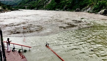
Rains lashed many places in Uttarakhand on Sunday, triggering landslides that blocked several roads while Ganga crossed the danger mark in Devprayag and the warning level in Haridwar due to heavy release of water from the dam on the Alaknanda river.
The Ganga was flowing at 463.20 metres following which water filled up in Sangam Ghat, Ramkund, Dhaneshwar Ghat and Fuladi Ghat. There was also a tremendous jump in the water level of the Ganga after 2,000-3,000 cusecs of water was released from the dam of the GVK hydroelectric project built on the Alaknanda river, PTI reported.
Also Read: Flood situation in Assam remains grim, around 1 lakh affected
The water level of the Ganga in Muni ki Reti area of Tehri near Rishikesh also increased to 339.60 metres, which is 0.10 metre above the warning level of 339.50 metres.
Officials said the Ganga crossed the warning level of 293 metres and reached 293.15 metres in Haridwar Sunday evening, adding that an alert has been issued in the low-lying areas due to the increased level of the river, PTI reported.
Meanwhile, the India Meteorological Department (IMD) has predicted “heavy to very heavy” rainfall over Uttarakhand, Himachal Pradesh, and Uttar Pradesh during the next five days. The Dehradun Meteorological Centre has issued an ‘orange’ alert, warning of heavy rain, in all 13 districts of Uttarakhand on Monday.
Also Read: Delhi govt to set up special camps for Aadhaar, other docs washed away in floods
A flood-like situation is prevailing in 71 villages of Laksar, Khanpur, Roorkee, Bhagwanpur and Haridwar tehsils due to incessant rains in the past few days.
The rescue and relief operations are being carried out with the help of the National Disaster Response Force (NDRF), State Disaster Response Force (SDRF), army and state police.
The abutment of a bridge on the Joshimath-Malari road was damaged due to debris and excess water flowing into the Girthi Ganga river at Niti Ghati in Chamoli district’s Joshimath.
