




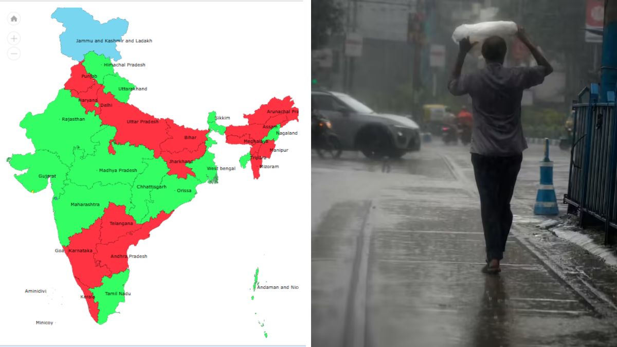
India continues to face an uneven southwest monsoon season despite signs of revival, with the country recording a 15% cumulative rainfall deficit between June 1 and July 26, according to the India Meteorological Department (IMD). While rainfall activity has picked up in recent days, large parts of the country remain below normal, particularly in the southern peninsula and northeastern states.
The IMD data shows India received 337.7 mm of rainfall against the long-period average (LPA) of 399.2 mm during the period. Rainfall on July 26 was also 35% below normal, with 19 states and Union Territories recording a single-day rainfall deficit of 60% or more.
Southern, northeastern states continue to face the biggest rainfall deficit
Among the four meteorological regions, South Peninsular India and East & Northeast India remain the worst affected, each reporting a 29% seasonal rainfall deficit.
In the south, Kerala has recorded a 37% deficit, receiving 764.5 mm against the normal 1,203.9 mm. Andhra Pradesh has also reported a 37% shortfall, while Puducherry (-54%), Telangana (-30%) and Karnataka (-25%) continue to experience below-normal rainfall.
The situation remains equally challenging in eastern and northeastern India. Meghalaya has registered the country’s highest rainfall deficit at 56%, followed by Manipur (-40%), Bihar (-39%), Assam (-39%) and Jharkhand (-34%).
In northern India, the overall regional deficit stands at 8%, largely offset by surplus rainfall in Ladakh (+199%) and Jammu & Kashmir (+29%). However, key agricultural states continue to remain rain deficient, with Punjab (-32%), Haryana (-25%), Uttar Pradesh (-22%) and Chandigarh (-34%) reporting below-normal rainfall.
Central India has fared relatively better, recording an overall 3% deficit. While Odisha (+18%), Gujarat (+13%) and Dadra & Nagar Haveli and Daman & Diu (+104%) have received excess rainfall, states such as Goa (-37%), Madhya Pradesh (-15%) and Chhattisgarh (-19%) continue to await sustained monsoon activity.
Monsoon revival to bring heavy rain across several states
The IMD said the southwest monsoon has now regained momentum after a prolonged weak phase, with a depression over the north Bay of Bengal expected to trigger widespread rainfall across eastern and central India.
The weather system was located about 130 km south-southeast of Sagar Island, 140 km southeast of Digha in West Bengal, 170 km east of Chandbali and 180 km east-southeast of Balasore in Odisha.
“It is very likely to move northwestwards, intensify further into a deep depression during the next 24 hours. It will cross north Odisha and West Bengal coasts, between Paradip and Sagar islands, around forenoon or noon on Monday,” the IMD said.
The weather office has issued an “intense rain” warning until July 30 for Gangetic West Bengal, Jharkhand, Bihar, Chhattisgarh, and eastern and western parts of Madhya Pradesh and Uttar Pradesh.
Extremely heavy rainfall is expected over coastal Odisha and West Bengal until Monday. Jagatsinghpur recorded 330 mm of rainfall during the 24 hours ending Sunday, while a red alert has been issued for Sundargarh, Keonjhar and Mayurbhanj districts of Odisha.
The IMD has advised fishermen not to venture into the sea along and off the Odisha coast until July 29, while schools in Jagatsinghpur and Mayurbhanj will remain closed on Monday. Jammu and Kashmir, Haryana, Punjab, Delhi and most parts of northeast India are also expected to receive intermittent rainfall until August 1.


