By Prashant Dikshit
A day before the Indian Independence day on 14th August 2023 India and China held the 19th round of military talks for resolving the border issues. They truly had nothing to show for this effort. Apart from homilies to focus on “building greater confidence with each other and avoiding clashes between the troops”, there has been no definitive forward movement. In fact that is what has been happening in the last few rounds of military talks.
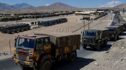
Prominent issues being faced by the Indian Forces are that they have lost their patrolling areas whilst Chinese troops are deeper into Indian territory. Legacy issues such as Depsang Plains and Demchok remain untouched. Whilst Demchok raises fears about further salami slicing but from a strategic point Depsang plains are truly cardinal for India. Over the years the Chinese Forces have built permanent structures and they are there to stay. Because it is not merely that the Chinese forces have encroached into India , as largely claimed by Indian commentators but a much larger nefarious design seems to unfold. It is around these lands that the big picture needs to be seen.
The Depsang Plains are close to DaulatBeg Oldie (DBO), India’s highest airstrip. The Karakoram Pass lies to the North West of DBO at a distance of approximately 17 to 18 KMs. This area is contiguous to Pak Occupied Kashmir (POK) and adjacent to the portion of POK comprising Shaksgam Valley which was illegally ceded by Pakistan to China in 1963 through a border agreement between the two. I would without any fear of contradictions conclude that the collusion between Pakistan and China commenced with this chicanery.
In 1959, Pakistan became concerned that Chinese maps showed areas of Pakistan in China. In 1961, President Ayub Khan sent a formal note to China but there was no reply.
Then Pakistan voted to grant China a seat in the United Nationsand the Chinese withdrew the disputed maps in January 1962, agreeing to enter border talks in March 1962. Negotiations between the nations officially began on October 13, 1962, and resulted in an agreement being signed on 2 March 1963betweeen foreign ministers Chen Yi for the Chinese and Zulfikar Ali Bhutto for Pakistan.When these actions were unfolding India was in the throes of the war unleashed by Chinese troops across Indian Borders.
Under this agreement Pakistan surrendered approximately 5,300 km2 (2,050 sq mi) of territory to China , to which it had no right in the first place as these were Indian territories. In return Pakistan received the area now known as GilgitBaltistan.
Gilgit-Baltistan is a part of the former princely state of Jammu and Kashmir that is “an integral part of India. A double conspiracy was thus hatched and brought to play.
The American Time, reporting on the matter in 1963, unequivocally wrote that Pakistan had further “dimmed hopes of settlement” of the Kashmir conflict between Pakistan and India that under this Sino-Pakistan Agreement, Pakistan’s control to a part of northern Kashmir was recognized by China.
The true nature of this expansionist conspiracy came to light when Pakistan was noticed issuing clearances to foreign mountaineering expeditions to the Siachen Glacier drawing a nefarious conclusion from the rulings of the Karachi Agreement signed by Indian and Pakistan’s military commanders in the presence of UN Military observers on 27th July 1949. According to the word and spirit of the agreement, NJ9842, is the northernmost demarcated point on this cease fire line from where it was supposed to go northwards to the Glaciers.
This was perfidiously interpreted by Pakistan as the last point from where it was supposedly joining at Karakoram pass and all territory contained in that enclosed segment as their lands. When this perfidy came to light, the Indira Gandhi government launched military expeditions and scotched the Sino Pak conspiracy. But India cannot lower its guard against an expansionist adversary who is eyeing the Indian base at Daulat Beg Oldi with its armour at a distance of 30 kms in the Depsang Plains. And that is a strategic overhang which will allow them access to the road being built under the CPEC and which traverses a territory ceded by Pakistan but claimed by India. That is the primary reason for India not joining the “One belt one road “scheme being pursued by China.
According to the Chinese regime their erstwhile Prime Minister Zhou en Li had publicly claimed that the Chinese Territories extend up to the Karakoram Pass. These claims were based on non – official and privately published maps, known as Shin Pao maps. In fact, it was only in 1956 the People’s Republic of China’s State Bureau of Surveying and Mapping was established dedicated towards these tasks.But the Shin Pao maps were used in annexing territories belonging to the Mongols, Uighurs, Kazaks , Tajiks and others in Military campaigns and were under suzerainty of the regime in Peking.
The Indian Government will do well to reevaluate their conclusions with respect to Chinese activities, stances and attitudes in view of the bigger picture and NOT back out from defending their territories merely to fulfil a diplomatic objective. They ought to share the realities with the nation
The author is a strategic affairs commentator.
Disclaimer: Views expressed are personal and do not reflect the official position or policy of Financial Express Online. Reproducing this content without permission is prohibited.
