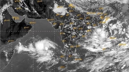
Cyclone Biparjoy approached the western coast of India and southern Pakistan after forming in the Arabian Sea. The storm, captured in a satellite image taken on June 14, was categorized as a level 1 storm on the Saffir-Simpson Wind Scale, with wind speeds of 129 kilometers per hour (80 miles per hour). After moving slowly north for eight days, the cyclone changed direction to the east.
Expected to hit land on June 15 at around 5:30 p.m. local time, Cyclone Biparjoy was anticipated to be a “very severe cyclonic storm” with sustained wind speeds ranging from 125 to 135 kilometers per hour (78 to 84 miles per hour). The storm was forecasted to impact India’s Gujarat state and the densely populated city of Karachi in Pakistan. In anticipation of the landfall, over 30,000 individuals and 200,000 animals were evacuated to safer areas.
Prior to reaching the coast, the cyclone had already brought strong winds, rainfall, and high tides to various regions in western India. Several deaths, including drownings off the coast of Mumbai, were reported as a result.
Cyclone Biparjoy developed on June 6 and benefited from unusually warm waters in the Arabian Sea, with sea surface temperatures reaching 31°C to 32°C (88°F to 90°F). These temperatures were 2°C to 4°C (3.6°F to 7.2°F) higher than the typical average. The warm waters played a role in the cyclone’s rapid intensification, which occurred twice during its existence. Between June 6 and 7, the wind speed increased from 55 to 139 kilometers per hour (34 to 86 miles per hour). Subsequently, between June 9 and 10, the wind speed rose from 120 to 196 kilometers per hour (75 to 122 miles per hour), elevating the cyclone to a level 3 storm.
The unusually warm sea surface temperatures contributed to the cyclone’s prolonged duration. The Meteorological Department of India stated that Cyclone Biparjoy had already surpassed eight days in the Arabian Sea and had the potential to become the longest-lived cyclone in the region, surpassing the record set by Kyarr in 2019, which lasted nine days and 15 hours.
Apart from NASA, UAE astronaut Sultan AlNeyadi also posted other pictures from the space:
Scientists studying the impact of oceans on tropical climate variability emphasized the role of climate change in the cyclone’s longevity. Raghu Murtugudde, a visiting professor at the Indian Institute of Technology Bombay, explained that warming in the upper ocean due to climate change results in cyclones moving slower and lasting longer.
Cyclones in the Arabian Sea have historically been rare, but their frequency has been increasing due to rising sea surface temperatures. A study conducted in 2021 by researchers in India revealed that cyclones in the region have become more frequent and prolonged, with ocean temperatures being a contributing factor.
The satellite image of Cyclone Biparjoy was captured by the Visible Infrared Imaging Radiometer Suite (VIIRS) on the NOAA-20 satellite. An astronaut aboard the International Space Station also photographed the cyclone on June 11, 2023. These images, along with the study of cyclones, contribute to our understanding of these weather phenomena.
Sultan captured a video of the cyclone approaching from up above in the space:
Cyclone Biparjoy is set to make landfall today. Nine states in India and neighbouring Pakistan are on high alert. After initially moving north for eight days, the cyclonic storm changed its course to the east on June 14. Currently, it is approaching the western coast of India and southern Pakistan after lingering in the Arabian Sea for over a week. A satellite image taken on June 14, captured by the Visible Infrared Imaging Radiometer Suite (VIIRS) on the NOAA-20 satellite, shows the storm a day before its target landfall. With wind speeds of 129 kilometers per hour (80 miles per hour), the cyclone is being categorised as a level 1 storm on the Saffir-Simpson Wind Scale.
Anticipated to make landfall on June 15 around 5:30 p.m. local time, Cyclone Biparjoy is expected to strike India’s western state of Gujarat and the densely populated city of Karachi in Pakistan as a “very severe cyclonic storm” with sustained wind speeds ranging from 125 to 135 kilometers per hour (78 to 84 miles per hour). In preparation for the impending landfall, Around 62,000 people and 200,000 animals have been evacuated to safer areas. It isanticipoated to landfall within the area of Keti Bandar Port located at Thatta district and Kutch district of Sindh, in India.
