Sikkim, famous for its pristine natural beauty, woke up to a deadly disaster earlier this week when the Lhonak Lake breached on the intervening night of Tuesday and Wednesday. According to the authorities, over 100 people are still missing after the flash floods. The state also suffered huge infra damages due to the flood tragedy. The dam of the country’s second biggest run-of-the-river hydropower project and a linking bridge were completely damaged in the flash floods.
The tragedy that struck North Sikkim on Wednesday, October 4 at 1 am resulted in 21 deaths so far. The flash flood was the result of the rising water level in Teesta river after the glacial lake, South Lhonak Lake, melted rapidly rushing in the downstream areas like Mangan, Gangtok, Pakyong and Namchi according to Sikkim State Disaster Management Authority (SSDMA).
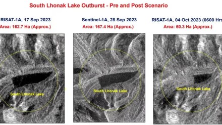
The Indian Space Research Organisation (ISRO) recently captured two images of South Lhonak Lake at different times to compare the rapidity of melted glaciers in the lake. As per ISRO, “It is observed that the lake has burst and about 105 hectares area has been drained out (28 September 2023 image versus 04 October 2023) which might have created a flash flood downstream,” while comparing images of September 28, 2023 and October 4, 2023.
How did melted glaciers lead to flash floods in Sikkim?
According to SSDMA press release on October 4, “The lake outburst in portions of Lhonak Lake in North Sikkim caused a rise in water levels with very high velocities near about 15m/sec, crossed the CWC (Centre Water Commission) Melli site measuring 227 m, near about 3m above Danger Level, at 0600 am.”
Additionally, for many years, government officials have been keeping an eye on the glacial lake. According to a Sikkim Forest and Environment Department report, the lake’s area has grown considerably during the previous 50 years.
Scientists have also come up with a few reasons behind the massive flood and one of them is the recent earthquake of 6.2 magnitude in Nepal and North India on Wednesday. The high tectonic movement of Earth blades may have possibly caused disturbance in Sikkim, which led to glacier movement at a speed of 15 meters per second. Another reason behind the disastrous flood is due to rising temperature of the planet that resulted in glaciers melting and later, glacial lake outburst flood (GLOF).
As per the reports by a senior cryosphere specialist, Miriam Jackson, of the International Centre for Integrated Mountain Development (ICIMOD), “Intense rain has led to this catastrophic situation in Sikkim where the rain has triggered a glacial lake outburst flood and damaged a dam and caused loss of life and caused further damage to roads and infrastructure. We observe that such extreme events increase in frequency as the climate continues to warm and takes us into unknown territory.”
It is possible that numerous settlements and assets along the river channel at Chungthang are susceptible to potential future GLOFs because of infrastructure that has been exposed to GLOFs in the Teesta valley. This points to the requirement for a thorough environmental impact assessment and potential GLOF risk reduction strategies.
