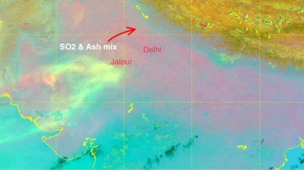
Ethiopia Volcanic Eruptions: Ethiopia’s Hayli Gubbi volcano eruption on Monday sent a huge cloud of ash and sulphur dioxide nearly 15 km into the sky. As the ash drifted over the Red Sea toward Yemen and Oman, it triggered warnings for flights in India. By 11 pm on Monday, the ash cloud had reached Delhi and is expected to move toward Punjab and Haryana on Tuesday. Because of this, IndiGo and Air India had to issue advisories for several flights on Monday. But how did this ash plume reach India from Ethiopia? Let’s find out.
How did Ethiopia’s ash plume reach India?
The volcano in Ethiopia exploded with such force that the ash shot up to about 10–15 km high, where the lower atmosphere meets the stratosphere. At this height, the hot air and gases may have helped the plume rise quickly. This layer is above most clouds and weather systems, so the ash could travel long distances without being disturbed.
Strong east-to-west winds high in the atmosphere then pushed the ash cloud across the Red Sea toward Yemen and Oman. Satellite images showed the plume stretching for hundreds of kilometres, staying mostly intact because the winds at that height were smooth and steady.
From there, the plume kept moving east-northeast and eventually entered India through western Gujarat and Rajasthan, passing areas like Jodhpur and Jaisalmer. By the afternoon, the edge of the cloud had also touched parts of Maharashtra. This route matches the movement of the subtropical jet stream, which shifts south during winter and guides airflows toward South Asia.
By around 10 pm IST, the main part of the ash cloud had reached Delhi-NCR, Haryana, Punjab and Uttar Pradesh, creating a short period of hazy skies. The ash moved through these regions quickly because the winds at high altitude were strong and stable, preventing the cloud from slowing down or getting stuck.
Overnight transit, composition and speed
IndiaMetSky Weather said that on November 24, the ash cloud was moving at around 100–120 km/h at an altitude of 15,000 to 25,000 feet. The plume carried volcanic ash, sulphur dioxide and tiny particles of glass and rock, and it was expected to rise up to 45,000 feet, which it later did, according to the service.
Although the eruption stopped, the ash already in the air continued to move north. It stretched from the Hayli Gubbi volcano region all the way to Gujarat.
The service also said the cloud would enter western India and then spread across several northern states. It had forecast that the plume would reach western Gujarat and then travel toward Rajasthan, northwest Maharashtra, Delhi, Haryana and Punjab by around 10 pm.
IMD says ash cloud to clear out from India by Tuesday evening
The ash plume has now spread from the Oman–Arabian Sea region into the northern and central plains of India. It is slowly moving toward the Himalayan foothills and is expected to affect northwest Uttar Pradesh, Uttarakhand and parts of the western Himalayas by early November 25, according to the IndiaMetSky Weather. It may also skim the Terai region of Nepal.
The India Meteorological Department (IMD) said that the ash clouds, which are drifting toward China, will clear out of India by 7:30 pm on Tuesday. Forecasts showed that the ash was likely to affect Gujarat, Delhi-NCR, Rajasthan, Punjab and Haryana earlier in the day.
Current and foreseen impact
The plume is drifting northeast at 100–130 km/h, with the core now over Delhi-NCR, Haryana, and adjoining Uttar Pradesh, extending back to Rajasthan and the Arabian Sea.
- Major impact is minimal at ground level due to the plume’s high elevation, but aviation disruptions are ongoing. Flights are facing delays, cancellations, and even diversions because of the ash plume potentially impacting visibility and aircraft engines. DGCA has advised airlines to avoid affected heights and regions and as per reports, airports are checking runways for ash. Airlines including Air India and IndiGo are monitoring the situation and as of now, no major issues have been reported yet but precautions are in place. Also, Mumbai airport has issued a notice for passengers on international routes passing through West Asia.
- Sky and Visibility Changes: Skies may look hazy and darker, similar to a dust storm, and as per reports, strong twilight colours may appear around sunrise and sunset. Widespread dark skies have not been seen yet but may appear later tonight.
- Air Quality: According to IndiaMetSky Weather’s latest update, surface air quality is mostly unchanged as the ash plume is hovering way above the ground. It says that the ash plume is too high to affect ground-level air in most places.
- Ashfall or Deposits: Light ash or dust settling on the ground is unlikely but small volcanic particles may appear in a few isolated spots in Rajasthan. Also, slight rise in sulphur dioxide is possible near the Himalayan foothills and Nepal’s Terai region. Slight SO₂ increase may occur in higher terrains like the Himalayas.
- No major impact on weather or climate expected in the short term and currently, no damage to crops or infrastructure has been reported.
