



Mumbai’s Ring Road Master Plan has now expanded to 10 routes, taking the proposed network to around 1,139 km across the Mumbai Metropolitan Region (MMR).
The latest addition, Ring 10, is around 27 km long. It will run from Pethe Marg through P. D’Mello Road/Wadi Bunder and the Eastern Freeway to Sewri-Worli, adding another east-west link to Mumbai’s road network.
According to Dr Sanjay Mukherjee, IAS, Metropolitan Commissioner, MMRDA, the aim of the plan is not only to help vehicles move faster but also to make travel more seamless and reduce the time people spend on the road.
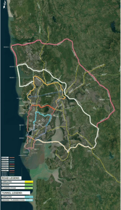
Ring 10 to add another east-west link
Ring 10 will cover a key section of central Mumbai, linking important road corridors between Pethe Marg, Wadi Bunder, the Eastern Freeway and Sewri-Worli.
The approximately 27-km route will form part of the larger ring-road network instead of functioning as an isolated road project. This approach is aimed at making better use of existing and upcoming infrastructure across the region.
The plan also highlights how smaller missing links can improve the performance of the wider road network. For instance, the final 1.4-km stretch of the Santacruz-Chembur Link Road (SCLR) helps complete around 10.3 km of signal-free east-west movement between Mumbai’s two major express highways.
Mumbai’s 10 ring roads: Route and length
The expanded master plan includes 10 interconnected routes covering different parts of Mumbai and the MMR. These include:
| Ring | Approx. Length | Key Connections / Coverage |
| Ring 1 | 27 km | Coastal Road, Sewri-Worli, Eastern Freeway, Orange Gate |
| Ring 2 | 34 km | Sea Link, Western Express Highway, SCLR, Eastern Express Highway, Eastern Freeway |
| Ring 3 | 67 km | Sea Link, Western Express Highway, JVLR, Eastern Freeway Extension |
| Ring 4 | 98 km | Versova Sea Link, GMLR/Northern Coastal Corridor, Eastern Spine |
| Ring 5 | 119 km | Dahisar, Bhayandar, Ghodbunder/Thane Coastal, ANS |
| Ring 6 | 185.6 km | Mira-Bhayandar, Alibaug, Virar, Thane, Eastern Spine |
| Ring 7 | 273.5 km | Uttan, Virar, Vadodara-Mumbai Expressway, Atal Setu |
| Ring 8 | 197 km | Atal Setu, Eastern Freeway, ANS, VME, NH-4B |
| Ring 9 | 110 km | Coastal Chain, Thane-Borivali Tunnel, Eastern Corridors |
| Ring 10 | 27 km | Pethe Marg, P. D’Mello Road/Wadi Bunder, Eastern Freeway, Sewri-Worli |
Focus on better use of existing roads
One of the key features of the plan is that the same road or infrastructure project can form part of more than one ring. This means the network does not necessarily require a completely new highway for every route.
Ring 1 and Ring 10, for instance, are both around 27 km, but they connect different parts of the existing and planned road network.
Together, the 10 routes are planned to create a much larger road network across the MMR. The focus is on connecting different corridors so that traffic has more ways to move across Mumbai, particularly between the eastern and western sides of the region.